
Post #78 - Venture Spotlight: MAPPEM Geophysics
- henry belfiori
- Aug 22, 2025
- 4 min read


As part of the In-Blue cohort with Narwhale Ventures, I recently connected with Andrew Weller from MAPPEM Geophysics, a French company quietly advancing one of the more underappreciated areas of the blue economy: marine electromagnetics.
From their base on the rugged coast of Brittany, MAPPEM has spent the past decade building a suite of proprietary systems that can image the seabed, detect buried objects, and monitor electromagnetic fields, all without invasive techniques. Their tech is already being used for projects across energy, archaeology, defence, and marine infrastructure, and now they’re actively exploring Southeast Asia, particularly Indonesia.
They are currently actively looking for partnerships in Indonesia and SEA, especially with local survey firms or pilot projects that showcase what their systems can do. If your work touches ports, power, seabed infrastructure, or even conservation baselining, get in touch!
1. The Problem – We Still Don’t Really Know What’s Beneath the Seafloor
Marine development is growing rapidly, offshore wind, HVDC cables, undersea pipelines, port expansion, subsea mining trials. But a common problem persists: we still lack accurate, non-invasive ways to see beneath the seabed.
Traditionally, developers rely on a mix of acoustic, seismic, and visual inspection tools. But these aren’t always fit for purpose, especially in areas with:
Buried UXOs (Unexploded Ordnance) or historic wrecks
Complex geology or gassy sediments
Shallow waters where vessel draft is limited
Sensitive habitats where disruption needs to be minimised
In many of these cases, existing tools either miss critical anomalies or pose environmental risks of their own. That’s the gap MAPPEM was built to close.
Starting as a spin-off from the University of Western Brittany, the team developed a new approach: towed marine electromagnetic systems that can detect resistivity changes in the subsurface, allowing for clearer, cleaner imaging of what lies below. And now, as demand for subsea development grows across Southeast Asia, these tools could play a critical role in balancing industrial growth with environmental caution.
2. The Solution – MAPPEM’s EM Toolkit in Action
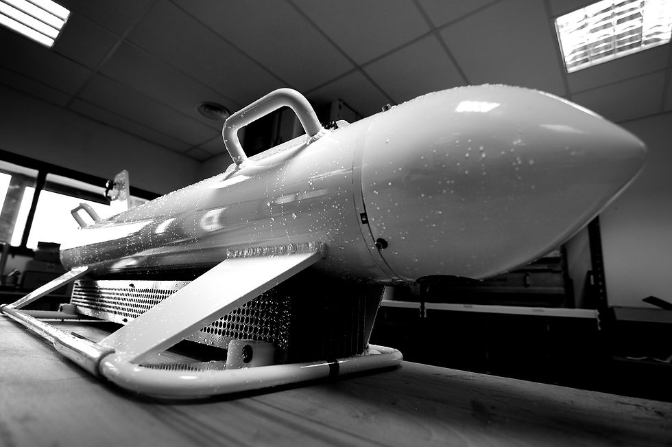
MAPPEM’s core innovation is a suite of marine electromagnetic (EM) systems designed to work in real-world conditions, from offshore environments to shallow harbours, from rugged geology to buried metallic objects.
Instead of relying on traditional seismic or sonar-based methods, their systems measure electrical resistivity and magnetic fields in the sub-seabed. This allows for high-resolution imaging of geology and the detection of non-visible objects, like UXOs, buried cables, pipelines, anchors, and even karstic voids.
Their current tech portfolio includes:
MAPPEM – The original towed system for resistivity imaging and buried object detection
MAPPEM-S – A lighter variant for very shallow waters (0–10m)
MAPPEM-3D – Detects and localises objects over a 5m swath, ideal for non-ferrous items like aluminium LMB mines
PASSEM – Towed sensors for measuring ambient electromagnetic fields from power cables or marine structures
STATEM – Autonomous seafloor stations for long-term EM monitoring and geothermal exploration

These tools are already in use across Europe for port development, offshore wind, HVDC cable studies, and even marine archaeology. What sets them apart is a balance of precision, low invasiveness, and adaptability, allowing clients to reduce risk, secure permits, and avoid costly surprises.
As MAPPEM now turns to Southeast Asia, these systems are especially relevant, given the region’s shallow, sediment-heavy coastlines, history of conflict zones (e.g. UXOs), and rising marine infrastructure activity.
3. The Team & Partnerships Behind MAPPEM
MAPPEM Geophysics was spun out of the University of Western Brittany in 2015 and remains anchored in France’s Finistère region, a fitting home for a company obsessed with understanding the seafloor.
Led by co-founders Dr Jean-François D’Eu (CEO) and Prof Pascal Tarits (Scientific Advisor), the team blends academic rigour with hands-on marine engineering. Their background in geophysics and marine electromagnetics underpins everything MAPPEM builds, from algorithm design to deployment protocols.
The broader team includes:
Dr Andrew Weller – Business Development Manager
Anne Maisonneuve – Scientific Computing Engineer
Quentin Daverdisse and Corentin Régné – Electronics Engineers
Dr Florent Colin – R&D Engineer
Paul Dubegny – Hydrographic Technician
Guillaume Arzel – Physical Measurements Technician
MAPPEM has delivered projects for a range of clients including EDF, Boskalis, Saipem, and French government bodies like DRASSM and the DGA. Their collaborations span port authorities, research institutes, offshore energy developers, and environmental regulators.
4. Future Possibilities – From UXOs to Deep Sea Impact Monitoring
While MAPPEM has already proven its value in nearshore geophysical imaging, UXO detection, and infrastructure risk mitigation, its potential stretches far beyond routine surveys.
With rising global interest in deep sea mining and its environmental risks, MAPPEM’s ability to monitor electromagnetic fields and map seabed properties could be a crucial asset. Their PASSEM and STATEM systems are already used to assess anthropogenic impacts, a capability that could easily extend to measuring baseline conditions and detecting disturbances around deep sea exploration zones.
As marine renewables scale up across Asia, particularly in countries like Indonesia and the Philippines, MAPPEM’s shallow and offshore systems offer an integrated toolkit for:
Coastal energy and port site investigations
Subsea cable routing and monitoring
Plastic pollution and shipwreck archaeology studies
Rapid-response environmental assessments after extreme weather
What makes MAPPEM exciting isn’t just the hardware, it’s their ambition to apply these tools where they’re most needed. As Southeast Asia ramps up investment in ocean industries, the ability to “see” beneath the seafloor with minimal environmental disruption could be game-changing.

5. Closing Remarks
MAPPEM Geophysics isn’t trying to reinvent the wheel, they’re building specialised tools to see beneath it. In an increasingly crowded ocean economy, that ability to read what’s happening below the seabed, without invasive methods, matters more than ever.
Their tech is proven, their clients include heavyweights in offshore infrastructure and defence, and they’re now focused on applying that expertise in new geographies like Southeast Asia. For startups and stakeholders working in subsea infrastructure, marine renewables, or even future-facing sectors like deep sea mining impact monitoring, MAPPEM represents a quiet but powerful enabler.
They’re not fundraising, but they are open to commercial partnerships, co-survey opportunities, and collaborations with local marine contractors, especially those active in Indonesia and the wider region.
If you’re building or operating in the Blue Economy and need better marine subsurface data or UXO mitigation, they’re well worth a conversation.
You can learn more at mappem-geophysics.com or reach out directly to Andrew Weller.
– Henry
OTI


Comments